


Le Sommet des Brosses

raymondfn
User

Length
10.7 km

Max alt
632 m

Uphill gradient
275 m
Km-Effort
14.4 km

Min alt
427 m

Downhill gradient
282 m
Boucle
Yes
Creation date :
2014-12-10 00:00:00.0
Updated on :
2014-12-10 00:00:00.0
3h09
Difficulty : Medium

FREE GPS app for hiking
 SityTrail
IGN / Geographical institutes
SityTrail Plus
The world is yours!
About
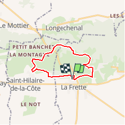
Trail Walking of 10.7 km to be discovered at Auvergne-Rhône-Alpes, Isère, La Frette. This trail is proposed by raymondfn.
Description
Fouinière
Départ de La Frette (Église)
PR - Pays de Bièvre-Valloire
Positioning
Country:
France
Region :
Auvergne-Rhône-Alpes
Department/Province :
Isère
Municipality :
La Frette
Location:
Unknown
Start:(Dec)
Start:(UTM)
684550 ; 5029313 (31T) N.
Comments